We Won! Congress Does Not Grant Military Expansions in Nevada
January 1, 2021 - In a roller-coaster ride for environmental groups--including Basin and Range Watch which originally broke the news about the proposed Air Force expansion in southern Nevada--the Senate voted today to override the President's veto on HR 6395 (the National Defense Authorization Act, NDAA) by 81-13. Those voting nay: Kennedy, Lee, Merkely, Paul, Braun, Markey, Widen, Booker, Sanders, Warren, Hawley, Cruz, and Cotton. For now, these deserts remain under public lands status, and the miltary operates under its usual status quo management and congressional renewal of land holdings.
President Trump had previously vetoed the massive NDAA which contained language protecting the Desert National Wildlife Refuge, and not approving expansion of the Nevada Test and Training Range, nor the Fallon military bombing range in Nevada.
Long-time Nevada conservationist John Hiatt in the Las Vegas Sun>> https://lasvegassun.com/news/2020/dec/20/desert-refuge-shouldnt-have-to-keep-dodging-bullet/
Stealth Land Grab in the Great Basin: Final Environmental Impact Statement Out For Fallon Range Training Complex Modernization
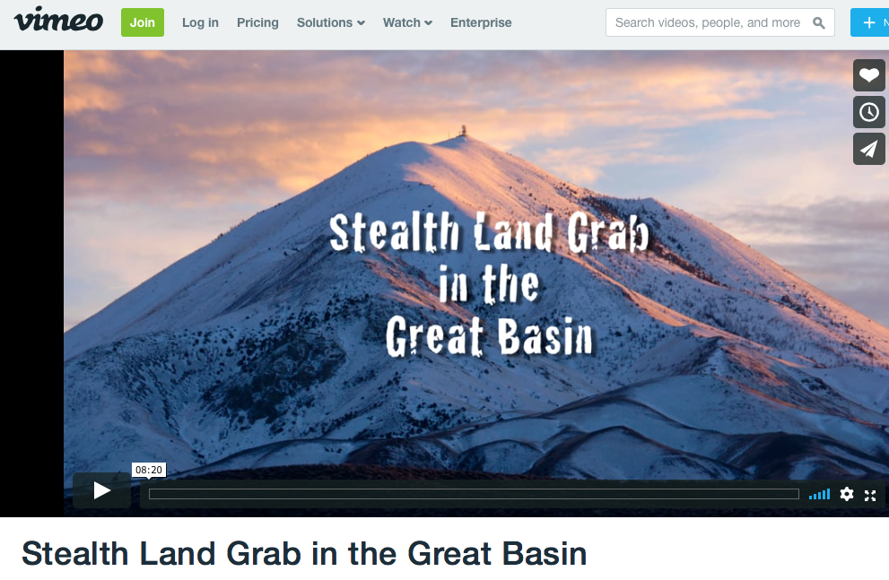
February 4, 2020 - Nevada - The Navy released its Final Environmental Impacts Statement (EIS) on January 10, 2020. Public review ends on February 10, 2020. See the video, above here: https://vimeo.com/285543688.
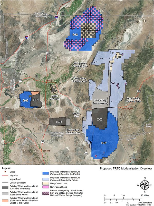
The Navy's Preferred Alternative is Alternative 3, which would tweak the expansion to avoid Fairview Peak, the Sand Springs Range, and access to the Rawhide Mine. Some other new areas would see a slight expansion or restricted area where consultation with the Navy and Bureau of Land Management (BLM) would be needed.
Recreationists are largely the losers in the Preferred Alternative, as this alternative would have significant impacts on public recreation: approximately 421,005 acres would no longer be accessible to the public. The Navy says impacts would be reduced to some extent by allowing bighorn sheep hunting within B-17 through a Memorandum of Agreement between NDOW and the Navy. Also, large racing events that currently occur near B-16, B-17, and B-19 would continue on those ranges in accordance with the requirements listed in the Large Event Race Activities section of Chapter 2 of the Final EIS. Additionally, B-17 would be shifted off the Sand Springs Range and Fairview Peak; therefore, these areas would remain publicly accessible.
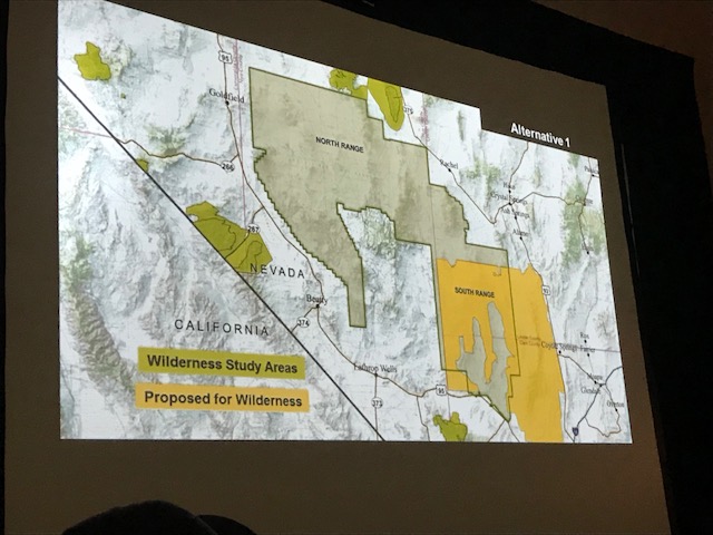
Under Alternative 3, the Navy is proposing that Congress remove the designation as a Wilderness Study Area from those portions of the Clan Alpine, Job Peak, and Stillwater Wilderness Study Areas within the Dixie Valley Training Area to accommodate training activities. The BLM would continue managing the remaining portions of the Wilderness Study Areas.
Read more >>here.
Military Legislative Push to Take Over Desert Bighorn Refuge Tries to Make End-Run Around Public Review Process
November 12, 2019 - Southern Nevada - The Department of Defense has lobbied heavily to use a large portion of the Desert National Wildlife Refuge in southern Nevada ‘primarily’ for military purposes, a newly-discovered draft bill says. The draft bill is authored by the Department of Defense and Department of Interior. It is planned to be a rider on the must-pass National Defense Authirization Act (NDAA) possibly in 2020. We have not seen who in Congress is sponsoring this bill yet, and it has not been introduced.
This draft legislation would carve out 1.1 million acres of Desert National Wildlife Refuge to be used only “secondarily” as a nature preserve, adding as much as 260,000 acres to the Air Force's test and training range. The push to expand has sparked fierce opposition from Moapa Band of Paiutes, whose ancestral lands extend across the testing range and refuge. Basin and Range Watch has been opposing the military takeovers in Nevada from the beginning.
Please contact your congressional representatives and tell them you oppose this bill! >>Senate. >>House of Representatives.
Read more at the Washington Post:
Nevada Test and Training Range Expansion Over Desert National Wildlife Refuge Taking Next Step
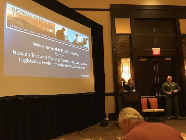
October 25, 2018 - The Air Force will publish a Notice of Availability (NOA) in the Federal Register on October 26, 2018 announcing the availability of the Final Legislative Environmental Impact Statement (EIS) for the Nevada Test and Training Range Land Withdrawal.
The Final Legislative EIS and supporting documents are available on the project website at www.nttrleis.com.
In our opinion the best course of action would be to get a petition to Congress going, asking them to oppose this expansion and keep the status quo. When we visited Representative Dina Titus in her Las Vegas office last year, this is what she recommended--she wanted to see a grassroots groundswell opposing the military takeover of so much public land. Stay tuned!
Fallon Naval Range Proposes Gigantic Land Grab in Nevada
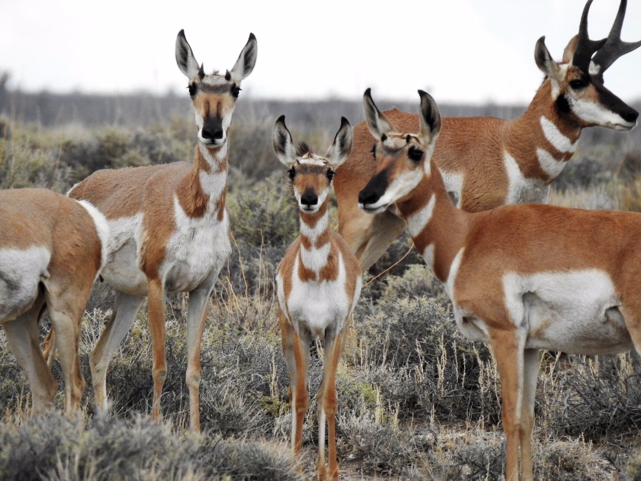
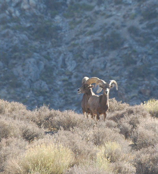
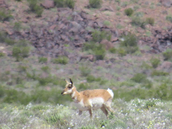
^Herds of Pronghorn antelope (Antilocapra americana) inhabit the basins proposed to be taken over by the military for new bombing ranges. (Photo: Kevin Emmerich)
August 19, 2018 - Central Nevada - The US Navy wants to close and bomb over 769,724.34 acres of public lands in Churchill, Lyon, Mineral, Nye, and Pershing Counties, Nevada. If Congress agrees to this, there will never be public access again. Several public roads would be closed and several private properties would also just be taken by the government. Beautiful mountains and basins would be closed and anyone caught there would be arrested. The Navy has already bombed 200,000 acres in Nevada. Tell Congress they don't need anymore!
The Fallon Range Training Complex Modernization: Expansion of Land Ranges, Airspace Modifications, and Public Land Withdrawal Renewal Environmental Impact Statement (EIS) will be released soon. See their website on the proposed Fallon Range Training Complex Modernization.
Watch this video Stealth Land Grab in the Great Basin by a friend of Basin and Range Watch:
Stealth Land Grab in the Great Basin from en on Vimeo.
See maps and more >>HERE.
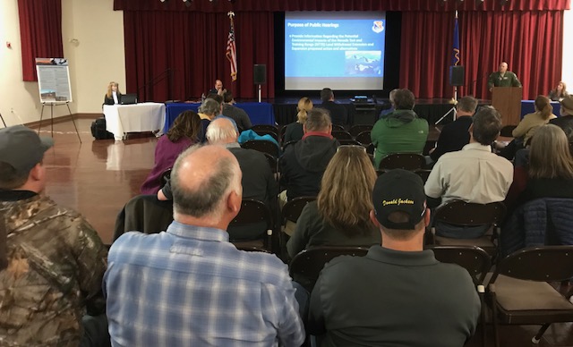
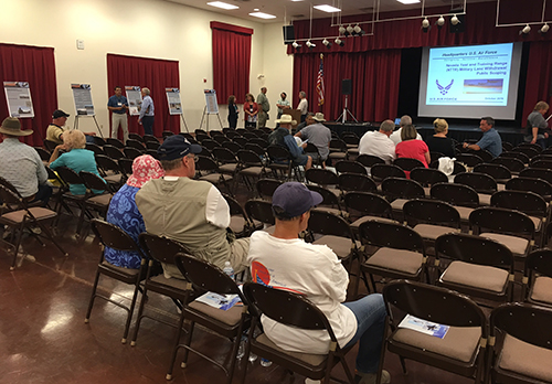
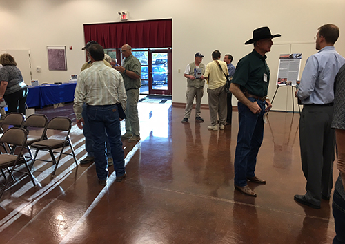
Public Meetings Show Huge Opposition to Southern Nevada Military Base Expansion
January 24, 2018 - North Las Vegas NV and Beatty NV - We attended public hearings hosted by the Air Force, and gave public comments opposing the plans to expand the Nellis Test and Training Range into 300,000 acres of public land. This includes over 200,000 acres of the Desert National Wildlife Refuge just north of Las Vegas, Nevada. Comment here: http://www.nttrleis.com/comment.aspx

Tribal members and chairmen, ranchers, hikers, environmental groups, 4x4 vehicle touring groups, hunters, veterans, and peace activists crowded into the Alliante Casino and Hotel conference center--over 200 people--to watch a presentation by the Air Force, and then give hours of public comment. We did not hear a single comment of support.
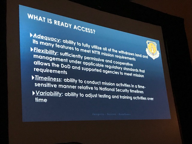
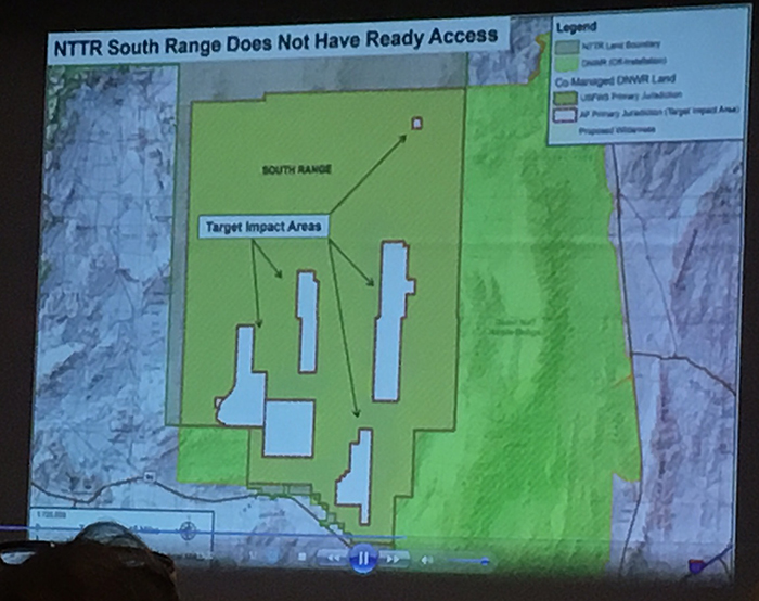
^Proposed Wilderness would be removed from the Desert National Wildlife Refuge in Alternatives 2 and 3, so that Ready Access would be allowed.
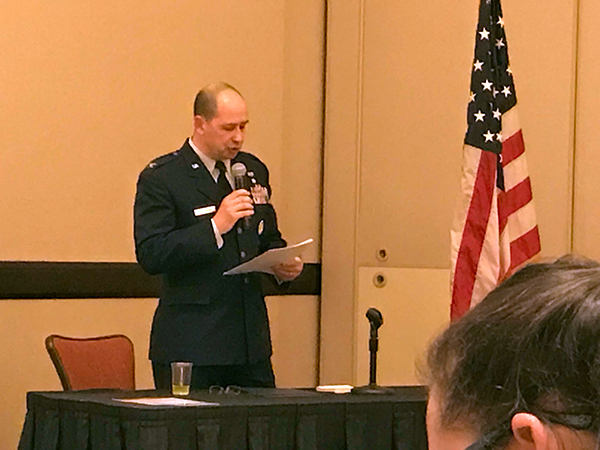
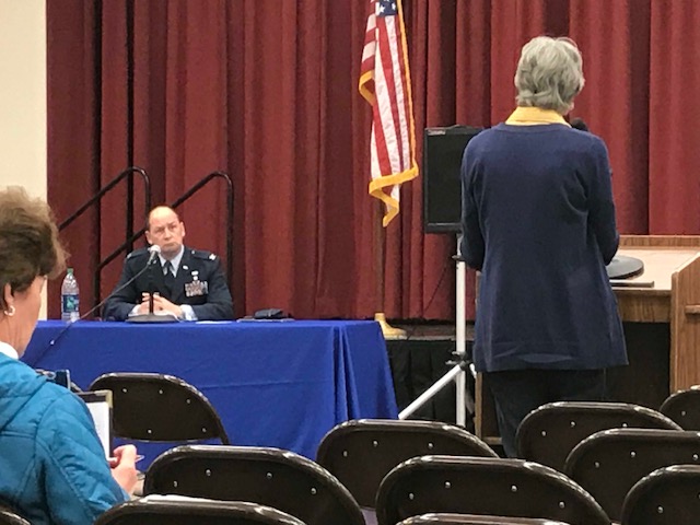
^The presiding officer.
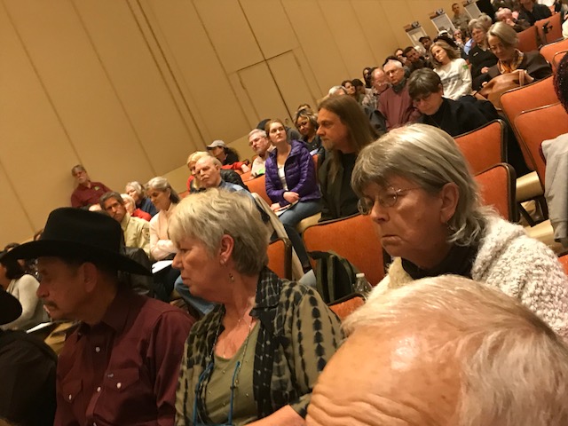
^The audience listening to the many public comments (over 50 people gave oral comments).
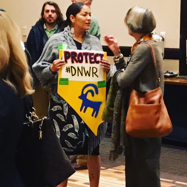
^Protester at the meeting.
^The audience attending the meeting in North Las Vegas was over 200 people, inlcuding Tribal members from local tribes (Moapa Pauite and Las Vegas Pauite).
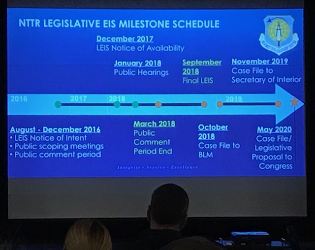
^The schedule of review for the proposed land withdrawal.
^Beatty meeting. Public comments raised concerns with the recreational uses of the public lands adjacent to the town, such as mountain biking, hiking, and Jeep tours. Other comments noted the significant biodiversity of the Amargosa River watershed.
Beatty resident comments during public meeting, discussing the value of the Amargosa River and diverse species living along it.
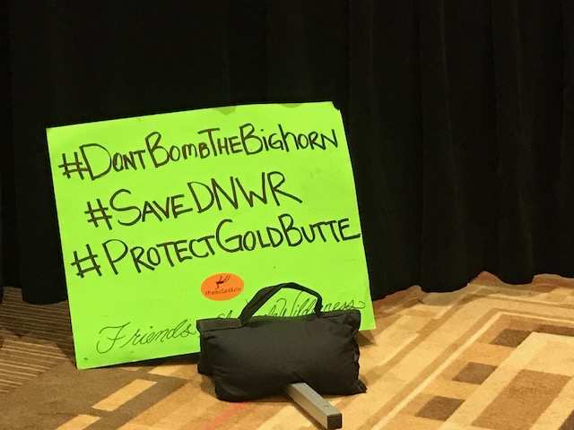
Save Desert National Wildlife Refuge
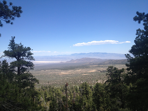
^View from the Cold Creek area of the Spring Mountains, looking eastward to the Sheep Range, showing part of the lower ranges that are within the Nellis Test and Training Range, and the taller forested Sheep Range that would be partly enclosed by the military. The Sheep Range has similar forests of ponderosa pine and limber pine on its higher elevations.
January 16, 2018 - We are reviewing the Draft Legislative Environmental Impact Statement (EIS) for the Nellis Test and Training Range (NTTR) public land withdrawal. Some of our comments follow. Public comments should be sent here: http://www.nttrleis.com/comment.aspx
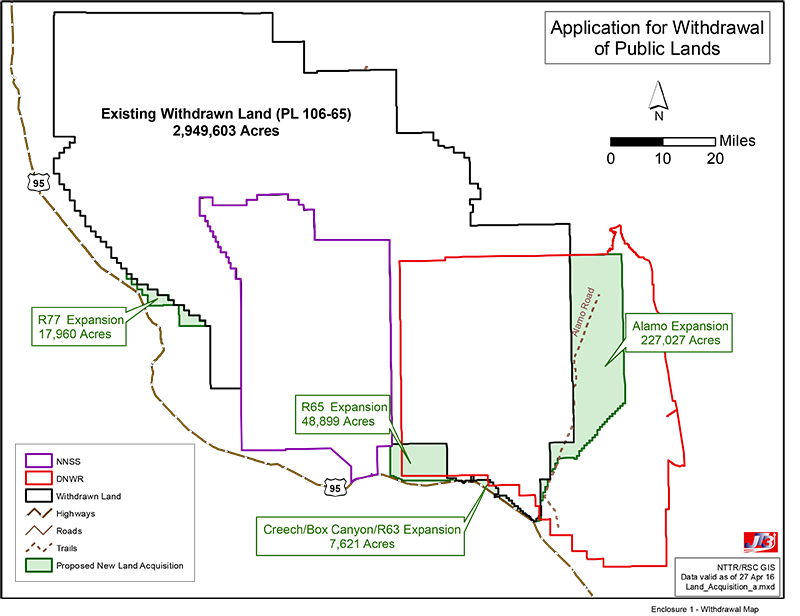
The Military Land Withdrawal Act of 1999 withdrew about 2.9 million acres of public land for military use at the Air Force Range in southern Nevada--a huge area of desert basins and mountains--and now that the current withdrawal is set to expire on November 6, 2021, the military wants to take more. Congress will have to make the final decision on the withdrawal through legislation.
We support the status quo, that Congress should renew the current withdrawal, maintaining the present acreage as Department of Defense (DOD) land, closed to the public.
We do not support any of the Alternatives that ask Congress to increase the size of the NTTR and take more public land (managed by US Fish and Wildlife Service and Bureau of Land Management).
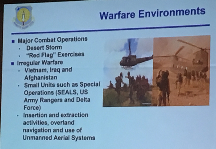
One argument we have against the need the military has for withdrawing more public land is that these enhanced Major Combat Operations and Irregular Warfare training can and do take place on the North Range of the NTTR, close to Tonopah NV. But the military wants to increase these kinds of training operations in the South Range, including part of the Sheep Range, and we believe a large reason for this is due to the increased drone training at adjacent Creech Air Force Base. This base has grown massively during the last ten years with new hangars and buildings, and is the center of drone warfare testing and training--Unmanned Aerial Systems.
Proposed Wilderness Areas, that are managed by the US Fish and Wildlife Service (USFWS) in the refuge as de facto Wilderness, seems to be a big part of the problem for the military, with its restrictions, and we suggest management changes could be made that would alleviate the need to withdraw more land from the public domain.
The Desert National Wildlife Refuge encompasses 1.6 million acres of prime habitat for bighorn sheep, desert tortoises, and other Mojave Desert species, as well as natural communities of Joshua trees, limestone endemic plants, sand dunes, natural desert rock pavement, big galleta-grass washes, and creosote-bursage shrublands. The mountains are cloaked in pinyon-juniper woodland with ponderosa pine forest as well. About half of the refuge overlaps with the NTTR and is closed to the public, but is still managed for bighorn sheep and wilderness values by both the USFWS and DOD. Almost 1.4 million acres have been proposed for Wilderness Areas by USFWS since 1971, and are managed as de facto wilderness.
This seems to be a particular sticking point, as the de facto wilderness management requires the Air Force to restrict activity below 4,000 feet elevation. Targets in the South Range are restricted to playas. A Memorandum of Understanding was signed in coordination with the Secretary of the Interior (for the refuge) and Secretary of the Air Force, renewed in 1997, describing how both agencies should manage the land.
We ask, instead of expanding the military base and deleting wilderness area proposals, which is the Air Force preference, could this MOU be re-written to allow for more military use in lands already in the South Range? If restrictions were loosened for warfare training within the existing NTTR co-managed with USFWS, the need take more public land would be lessened.
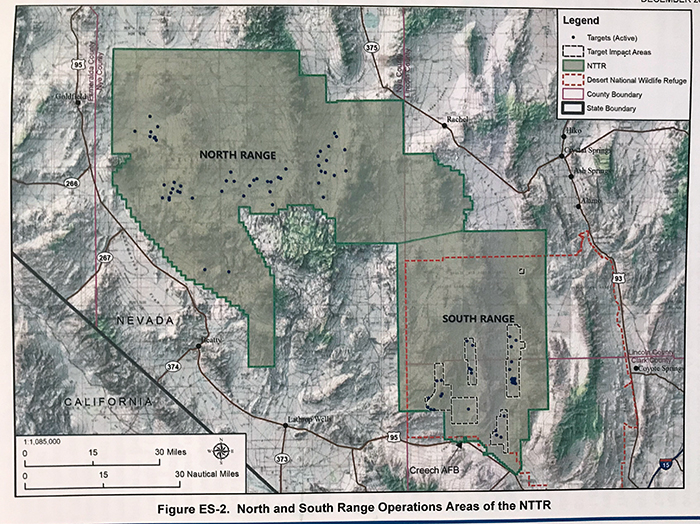
^Nellis Test and Training Range in southern Nevada, with the red dotted line showing the boundary of the Desert National Wildlife Refuge. Creech Air Force Base is adjacent to the South Range, apparently a main reason the military wants to expand training operations in this part of the Range.
Irregular Warfare exercises would include expanded ground training supported by air and vehicle operations, using blank ammunition with small arms, hand flares, smoke grenades, and paint balls. Helicopters and fixed wing-aircraft will be used for troop insertion, as well as increases drone support. Ground vehicle travel will not only be restricted to existing roads--All-terrain vehicles (dune buggies) will be used overland in mountains and basins. Threat Emitter operations could also effect wildlife--electronic warfare emitters on mountain rides. How will these ground and air training programs impact bighorn sheep?
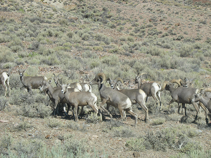
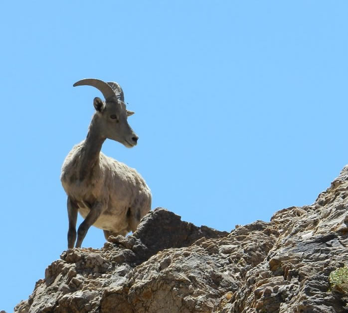
^Desert bighorn sheep herd in Nevada.
To increase security and reduce trespass into the Range, the Air Force is proposing to build fences across the desert and mountains to better delineate the boundary. But this may hinder bighorn sheep movements. An alternative could be to put up signs in places, and better educate the public with interpretive displays both in the Refuge visitor center and out along routes. Better maps could be made and distributed.
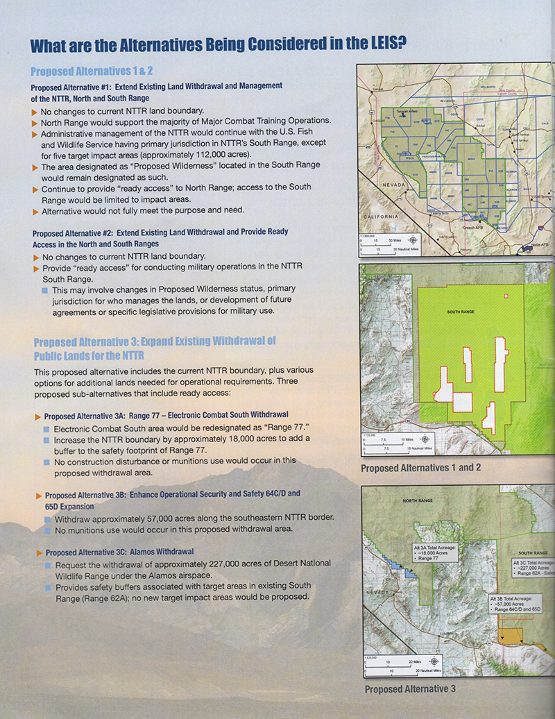
We support Alternative 1, which extends the existing status quo, allowing the military to continue using the NTTR as it is now.
Alternative 2 is similar but allows the Air Force to have "ready access" in the North and South Ranges, with increased training activities and aircraft operations. Lands managed as de facto Wilderness Areas would be eliminated by Congress, by 42% (590,000 acres) in the lands overlapping the Desert National Wildlife Refuge and the NTTR. But no expansion would occur, rather a jurisdictional take-over. This management change would allow more noise, aircraft strikes, increased use of target areas, construction of new facilities, targets, and roads, as well as placement of Threat Emitters in the mountains. Increased ground training would impact soils. Would depleted uranium munitions be used in new areas now restricted from live-fire targets?
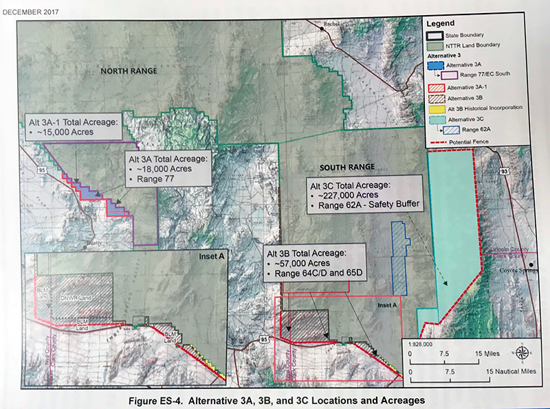
We do not support Alternative 3, the expansion of the military range and withdrawal of of public lands. Various sub-alternatives describe BLM lands near Beatty (18,000 acres) and Indian Springs (57,000 acres) to be withdrawn, and a large portion of the Sheep Range and basins in the Desert National Wildlife Refuge (about 227,000 acres)--the Alamo Withdrawal. Lands managed as de facto Wilderness would be reduced in the Alamo Withdrawal. So the maximum expansion of military base over Desert National Wildlife Refuge would be 284,000 acres (Alternatives 3B and 3C, the corner of the Refuge west of Indian Springs, and the Alamo Withdrawal).
The Beatty area BLM public land withdrawal would impact mountain bike trails that local private land-owners have developed to help the old mining town find new economic life with eco-tourism and mountain bike tourism. The area has extensive Joshua tree woodlands, pristine desert, a population of pronghorn antelope, and historical townsites.
For communities downriver of the Amargosa River headwaters in the Pahute Mesa (within the Nevada Test Site), Alternative 3 withdrawals in the Beatty area would restrict county hydrologist access to test wells that monitor Tritium content in groundwater. Two hydrogen bomb tests were conducted underground in the Pahute Mesa, which directly affect Amargosa River water, and the public needs to maintain access to these important test wells to monitor any radioactive flow downstream. Access protocols for water sampling should be a priority.
^Pronghorn antelope seen in eastern Sarcobatus Flat, Nye County, Nevada in 2016 during a spring wildflower bloom. This is within ten miles of the proposed military expansion in the upper Amargosa River watershed north of Beatty.
The Alamo Withdrawal over the Desert National Wildlife Refuge has been modified since scoping to remove popular areas for hikers such as the Hidden Forest. New dirt runways would be constructed on or by playas, ground training would occur, air support, new road construction, and 60 miles of new fencing. No new live-fire targets would occur in expansion areas. But 15 half-acre construction pads would be developed for such facilities as Threat Emitters, and some of these would have noisy generators. Fencing would be built. Hunting would be allowed with restrictions. Specific culturally important sites would be allowed access by Tribes. But all hikers and OHV recreationists would be banned. Some existing backcountry dirt road routes would be closed. Mining claims would be withdrawn. Water rights would be impacted. Significant light pollution and military training would happen in a previously "untrammeled landscape", and "would change the area from 'undeveloped' to one with human development and interference" (page ES-26). An increase in depleted uranium metal deposition would occur apparently.
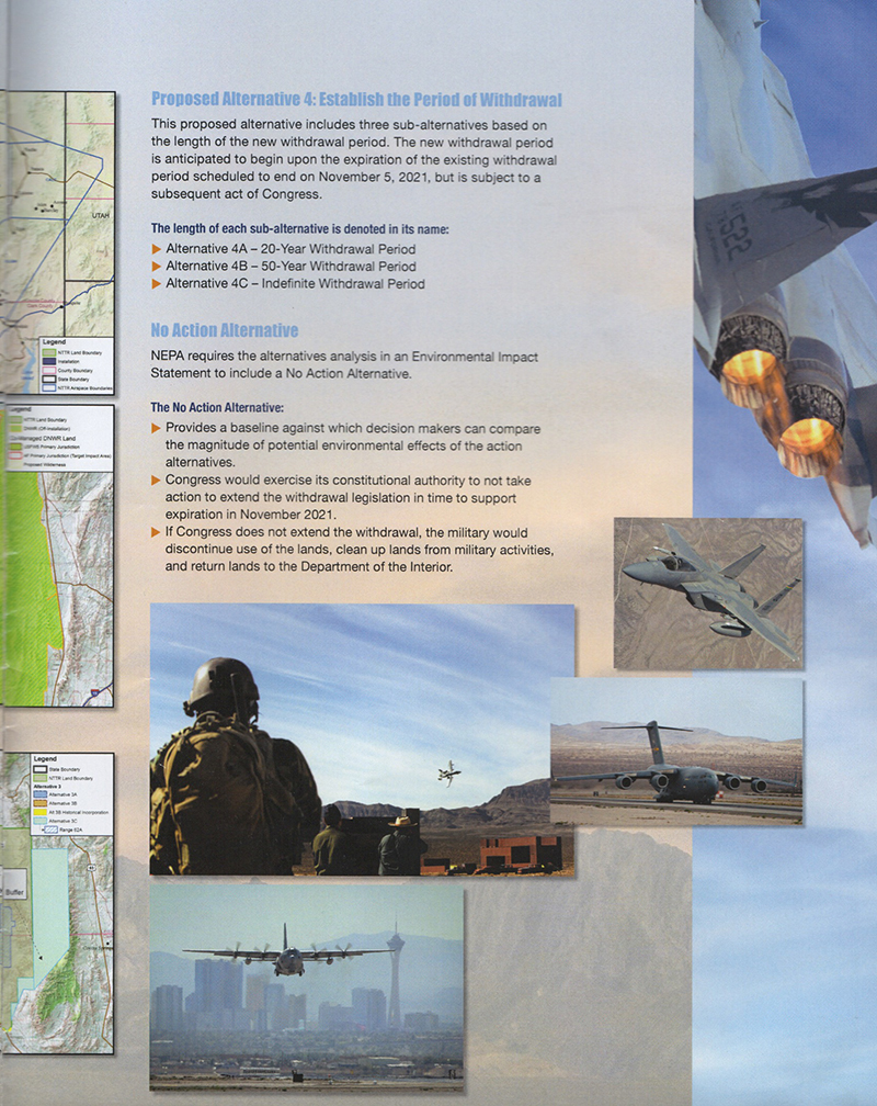
Alternative 4 discusses various lengths of time the Withdrawal Period would last for: a 20-year withdrawal, a 50-year withdrawal, and an Indefinite withdrawal period. We support a 20-year withdrawal period, so the the public, through Congress, can remain active in the future of these lands.
A No Action Alternative is included as a matter of review under the National Environmental Policy Act (NEPA), that would mean Congress would take no action to continue the withdrawal of public lands for military use, basically reverting the area back to BLM and the Desert National Wildlife Refuge. We believe this is not a viable alternative since military use of the NTTR has been ongoing now for decades, including live fire bombing of targets, including the use of depleted uranium rounds, that the military carefully cleans up. But these lands should remain as military training grounds. We disagree with expanding the NTTR, however.
See also the very good article by Mojave Desert Blog on this military expansion:
http://www.mojavedesertblog.com/2017/12/air-force-proposal-to-close-public.html
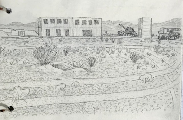
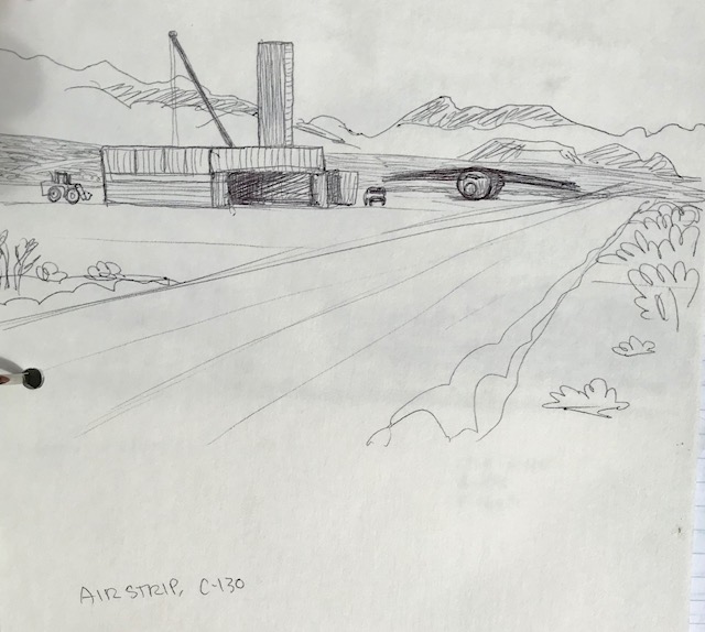
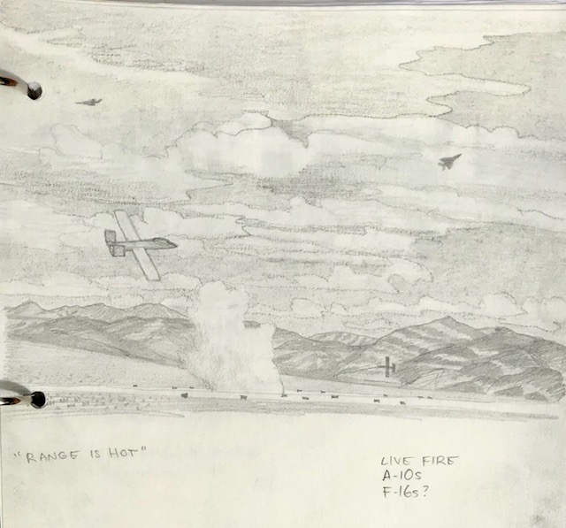
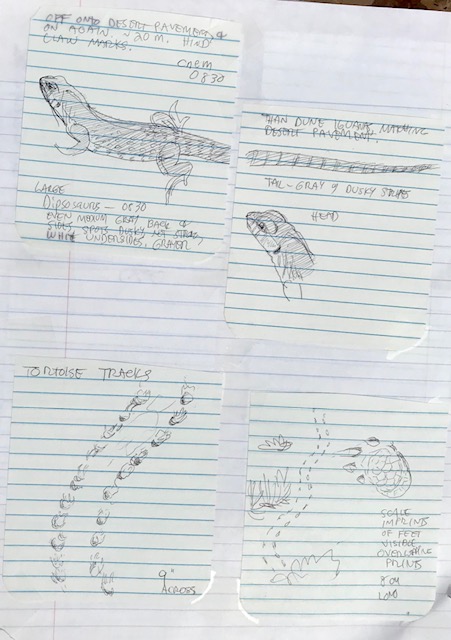
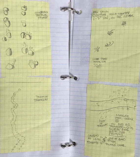
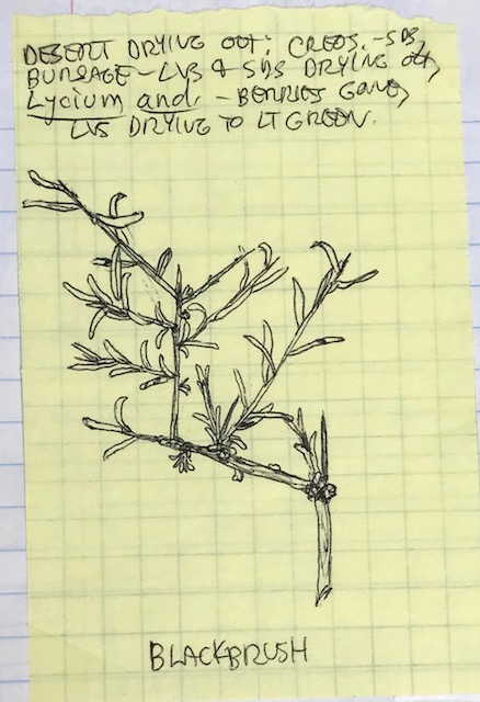
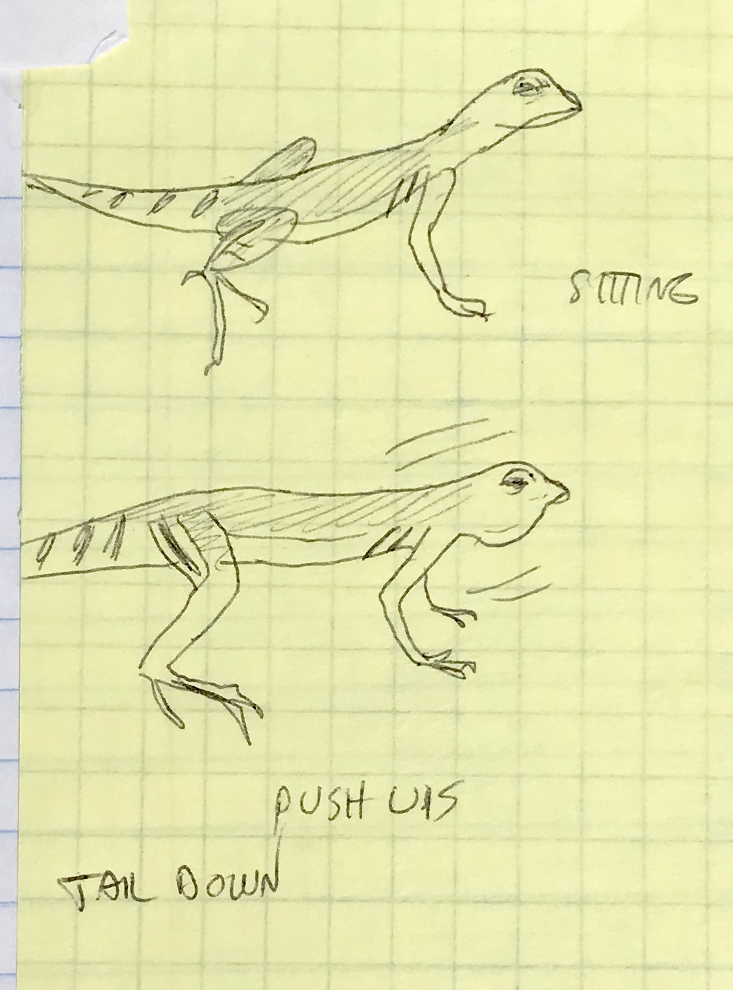
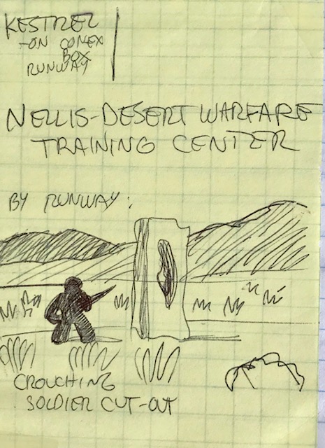
The following field notes and sketches are by Laura Cunningham, who worked as a biologist on the NTTR South Range in 2004, at the Dogbone Lake target:
Nellis Military Base Expansion Draft Environmental Review Document Out
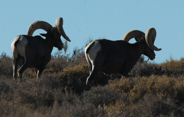
^Will desert bighron sheep in the Sheep Range, Desert National Wildlife Refuge, be threatened with increase noise, war games, live-fire ordinance testing, road-building and training exercises?
December 8, 2017 - The Legislative Environmental Impact Statement for the Nellis Test and Training Range Expansion, which will possibly take 220,000 acres of the US Fish and Wildlife Service Desert National Wildlife Refuge in southern Nevada, has been released.
The new Desert Report has a good article explaining the basics and here is the web page from DOD: http://www.nttrleis.com/announcements.aspx.
We met with Congresswoman Dina Titus, (D-Nevada) about this issue ten days ago. She represents many people in her district who support the Desert National Wildlife Refuge, and we made her aware of the how the area protects desert bighorn sheep, and has a recreational value to the public.
This decision will be made by a DOD team designated by Congress so it is very important to tell Congress you oppose the expansion now! More on this soon.
Here is the announcement:
The Air Force has published a Notice of Availability (NOA) in the Federal Register announcing the availability of the Draft Legislative Environmental Impact Statement (EIS) for the Nevada Test and Training Range Land Withdrawal. The publication of the NOA began a 90-day public comment period which will end on 8 March, 2018.
The Draft Legislative EIS and supporting documents are available on the project website at www.nttrleis.com. The Draft Legislative EIS is also available at various libraries and repositories - a list of locations is also provided on the project website.
The Air Force plans to hold five public hearings from 5:30 p.m. to 9 p.m. on the dates and at the locations listed below. During the meetings, the Air Force will provide information on the potential environmental impacts associated with the proposed action and solicit public comments on the Draft LEIS.
•Wednesday, January 17, 2018: Caliente Elementary School, 289 Lincoln Street, Caliente, NV 89008
•Thursday, January 18, 2018: Pahranagat Valley High School, 151 S. Main Street, Alamo, NV 89001
•Tuesday, January 23, 2018: Aliante Hotel, 7300 Aliante Parkway, North Las Vegas, NV 89084
•Wednesday, January 24, 2018: Beatty Community Center, 100 A Avenue South, Beatty, NV 89003
•Thursday, January 25, 2018: Tonopah Convention Center, 301 Brougher Avenue, Tonopah, NV 89049
The agenda for each public hearing is as follows:
•5:30 p.m. to 6:15 p.m. – Open House and written comment submission
•6:15 p.m. to 7:00 p.m. – Air Force Presentation
•7:00 p.m. to 9:00 p.m. – Public Hearing/Oral Comments
The project website (www.nttrleis.com) can be used to submit comments on the Draft Legislative EIS or comments may also be submitted by mail to the 99th Air Base Wing Public Affairs, 4430 Grissom Ave., Ste. 107, Nellis AFB, NV 89191. Please direct any requests for information or other inquiries to the 99th Air Base Wing Public Affairs, 4430 Grissom Ave., Ste. 107, Nellis AFB, NV 89191, by e-mail at 99ABW.PAOutreach@us.af.mil, or by phone at (702) 652-2750.
Thank you,
Michael Ackerman
Program Manager
NEPA Division (AFCEC/CZN)
Military Expansion into Desert National Wildlife Refuge: Environmental Review to Start this Winter
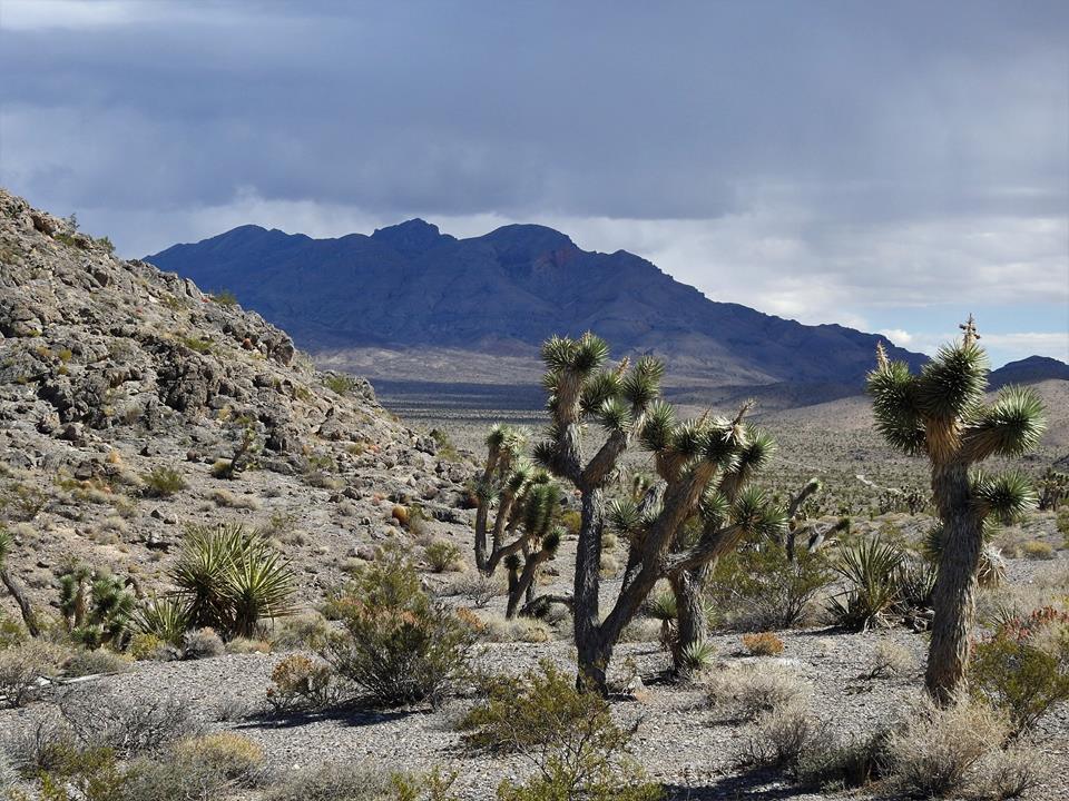
^Limestone mountains and Joshua trees in the Desert National Wildlife Refuge.
November 1, 2017 - Southern Nevada - We have found out through personal communication that the Legislative Environmental Impact Statement for the proposed 300,000 acre expansion of the Nellis Air Force Base will be released on December 8th, 2017. Nellis wants to expand on 220,000 acres of public lands on the Desert National Wildlife Refuge, Nevada to make a military buffer for increased bombing. Several new roads, runways, towers and additional infrastructure would be built in the refuge and public access would be cut odd. An additional 80,000 acres of BLM land is also being looked at.
Public meetings have been scheduled, but the schedule has still not officially released yet. Here is the schedule:
Jan. 17 - Caliente, NV (Caliente Elementary School)
Jan. 18 - Alamo, NV (Pahranagat Valley High School)
Jan. 23 - Las Vegas (Aliante Casino + Hotel)
Jan. 24 - Beatty, NV (Beatty Community Center)
Jan. 25 - Tonopah, NV (Tonopah Convention Center)
5:00-6:30 pm (open house/comments)
6:30-7:00 pm (USAF presentation)
7:00-9:00 pm (open house/comments)
Comments will not be accepted in a public form. You will have to submit them privately to a court reporter. Information can be viewed here: http://www.nttrleis.com/index.aspx
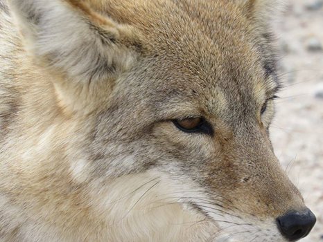
Marines Order Coyote Kill along with Tortoise Translocation
March 22, 2017 - Red Alert: Call the 29 Palms Marine Corps base Public Affairs office at (760) 830-5310 and tell them not to start killing coyotes!
The Marine Corps Air Ground Combat Center is hosting a coyote hunt in an attempt to "save" the 1,500 desert tortoises they are about to move (translocate) off of 49,000 acres of Mojave Desert habitat for large military vehicle maneuvers. This is definitely not a "conservation action" as described below. It is impossible to remove coyotes. Past attempts to kill coyotes to save tortoises have not worked. If the Marines want to help 1,500 desert tortoises, the best action is to avoid expanding the base and leave the tortoises alone in their natural habitat.
This is a major admonition that desert tortoise translocations results in unacceptably high mortality, as tortoises are removed from their home ranges and released in areas strange to them where they do not have a memory of their favored burrows and other shelters. Translocated tortoises often travel long distances in an attempt to return to their familiar home ranges, and during these wanderings they become very susceptible to natural predations by native species such as coyotes and ravens.
This is not the fault of the coyotes, but the fault of modern pressures to develop the desert and expand destructive management practices such as military maneuvers into the homes of tortoises and coyotes. The so-called mitigation of killing coyotes is a false action that will not help recover the tortoise, and will only disrupt desert ecosystems more. Coyotes are a native, natural species that belong to the Mojave Desert. Tanks, Humvees, bombing, live-fire exercises, and military maneuvers do not belong to the desert. The military has enough land to carry out tests and training, they do not need to keep expanding.
An unacceptably high tortoise mortality resulted from the Ft. Irwin Army base expansion where nearly 50% of desert tortoises suffered mortality after being removed. Coyotes were blamed for predating many tortoises, and claims were made that a drought was increasing coyote predation on tortoises. But the evidence we have seen is that translocation itself is the cause of mortality, not any unusually high number of coyotes, or drought conditions, or subsidized predators. The simple cause is the current politically-agreed upon need to take more desert tortoise habitat for destructive development and military usage. In other words, the continued expansion of the Military-Industrial Complex. This coyote hunt shows that the military believes a similar high tortoise mortality is expected, without extreme measures to "protect" translocated tortoises who are placed far from their safe home ranges.
The Coyote hunt should be halted, and if tortoises are to be translocated, other, better mitigation measures should be taken in order to safeguard translocated tortoises, such as more artificial burrows constructed and tortoises watched over and monitored with GPS tags to track their movement at a much higher intensity then simply dumping them into new territory and expecting them to fend for themselves. We cannot rely on translocation to save tortoises, it is a failed mitigation measure. But blaming coyotes is not the answer.
Call the 29 Palms Marine Corps base Public Affairs office at (760) 830-5310 and tell them not to start killing coyotes!
The information we obtained from the Marine Base reads:
"Folks,
MCAGCC [Marine Corps Air Ground Combat Center] will host a coyote hunt ca. 0600-2200h each Saturday and Sunday 25 & 26 March 2017 in the Sand Hill, West, Gypsum Ridge, East, Cleghorn Lake RTA.
A sixth RTA (Acorn or Prospect) may be included. There will be two hunters per RTA on each day, with their focus probably dawn and dusk (e.g., two hunters in Sand Hill on Saturday, and two hunters in Sand Hill on Sunday). See program notice below.
"The hunters must have a current CA Hunting license (which requires Hunter Safety Training) and obey all normal rules (e.g., speed limits, no off-MSR vehicle traffic in Restricted Areas) for use of the RTA. The CLEOs will operate the program, hunters will be equipped with range radios to communicate with BEARMAT.
"CALL FOR CONSERVATION ACTION PARTICIPATION In support of the Natural Resources and Environmental Affairs (NREA) Division's coyote depredation program, volunteers are invited to participate in a coyote depredation hunt. To be considered, please send your name via an email to russell.elswick@usmc.mil NLT Friday, March 17, 2017 with your full name, contact phone number and email address. After a lottery draw, a limited number of volunteers will be notified and invited by NREA to participate in the event. To participate, volunteers must be available for an in-brief at 1830 on 24 Mar, possess a current California hunting license, and have a 4x4 transport to get them out to the Range Training Areas where the hunt will occur. The hunt will go on 25 and 26 Mar, and each volunteer will be assigned a day and hunting area. The purpose of the depredation program is to reduce the numbers of coyotes that are unnaturally inflated in the local area due to human subsidies. Elevated coyote numbers prove a safety risk to residents, and are a significant factor in the mortality of the desert tortoise."
Details of Nellis Test and Training Range Expansion Plans Discussed at Scoping Meeting
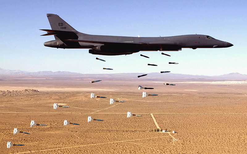
^B-1 Bomber.
October 12, 2016 - Beatty NV - We attended the scoping meeting for Nellis Test and Training Range (NTTR) military base expansion in Beatty, which was well-attended by the town and many ranchers from hundreds of miles away. The base proposes to expand into adjacent public land managed by the Bureau of Land Management (BLM) and US Fish and Wildlife Service (at the Desert National Wildlife Refuge).
Public comments will be collected until December 10, 2016. Submit comments here: http://www.nttrleis.com/comment.aspx
See the story by Wynne Benti in the Sierra Club Desert Report.
Legislative Environmental Review Statement
This is a Legislative Environmental Review Statement under the National Environmental Policy Act (NEPA), of which we still have many questions that we are trying to find answers to. It is complex. The Department of the Air Force will follow the applicable procedures set forth in Bureau of Land Management regulations at Title 43 Code of Federal Regulations (CFR) Part 2300 implementing the Department of Interior’s authority to process federal land withdrawal applications. So this review will go through the Department of the Interior. But the Air Force is the lead agency for the LEIS.
Congress has reserved the authority for renewing the NTTR land withdrawal for itself, through the Defense Withdrawal Act of 1958 (43 USC Sections 155–158), and will make the final decision as to whether or not to renew the NTTR land withdrawal. The current NTTR land withdrawal expires in 2021 unless legislation is enacted extending it. What this review process and decision would do is change the usual extension from the status quo of current military land acreage and co-management with Desert National Wildlife Refuge, to a large expansion of 301,507 acres over the wildlife refuge, BLM land, and changes to how the military ranges are used (with an increase in live fire bombing). More of the Desert National Wildlife Refuge would be off-limits to the public, such as Hidden Forest. The Corn Creek Visitor Center area would remain open, and the southeast part of the refuge. Alamo Road would apparently be closed.
Why Does the Military Need More Land?
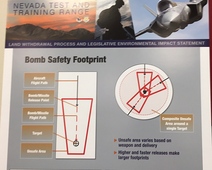
At the meeting we asked these questions. Air Force personnel and contractors told us this is because of the "one-in-a-million" chance of debris or shrapnel leaving the target area during a bomb drop from different angles.
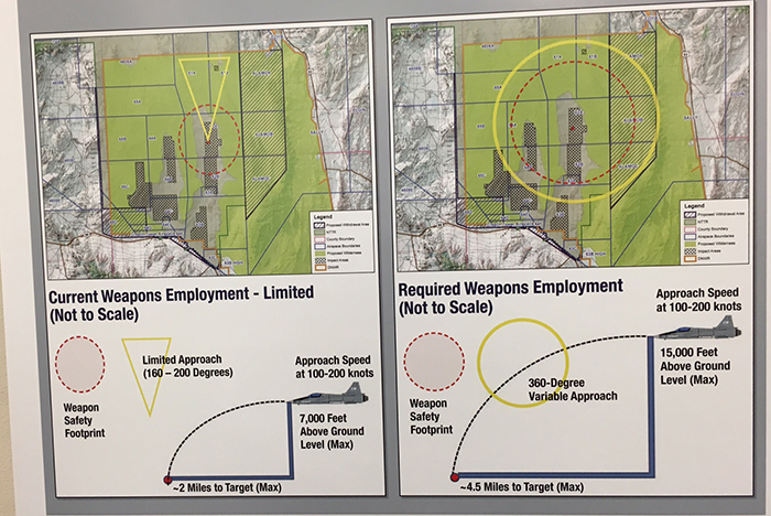
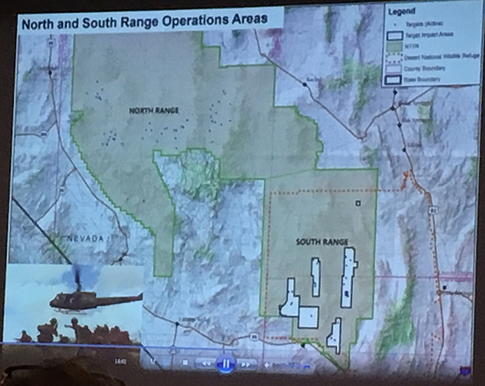
The North Range of the NTTR already allows more unrestricted and broad live fire bombing tests and training. But the South Range does not have this allowance, and has very restricted targets and approaches to targets for live fire tests.
The Air Force wants the ability to do training where aircraft come in from different angles, in a 360-degree range, to do live fire bombing of targets in the South Range. Currently they can only fly in from one direction in the basin where targets are, due to the configuration of mountain ridges. Shrapnel and debris is carefully calculated to spread in a certain direction, and not aim outside of military boundaries.
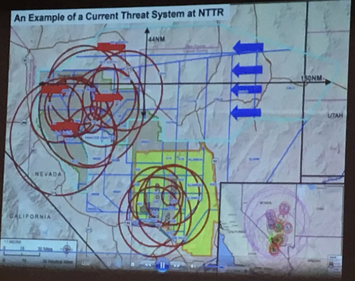
The Air Force wants to be able to fly in faster and higher, to more realistically train in modern warfare conditions, over the Sheep Range and lower ridges, where electronic countermeasure devices would be constructed to imitate enemy stands.
Aircraft would fly in from other directions as well under this proposal so that there is an extremely remote possibility that debris or shrapnel from high impacts on targets would fling over some lower mountains into adjacent public land sections, or misfires would occur.
No new Target Impact Areas would be developed, only present targets would be used in training. But a 360 degree approach to targets, at faster speeds for live fire training is what is needed, according to the Air Force. They said this would be a more realistic warfare environment.
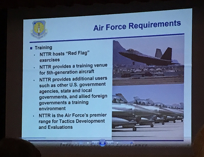
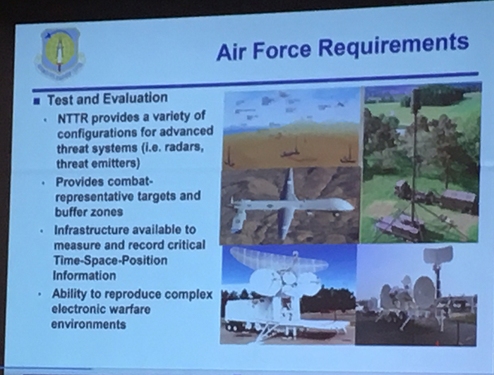
Wanting to expand Safety Buffer zones and increase war game complexity, the Air Force is anticipating Fifth generation F-35 aircraft becoming available, and new advanced weapons systems. Intermediate to advanced training with more modernized systems will be fielded. Currently war games are not allowed in the mountains of the South Range, and these alternatives would open up access to the military. Increased mountain warfare tests and training are sought.
Drone Testing
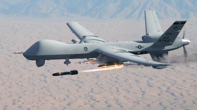
^Reaper drone.
This expanded use of live fire bombing in the South Range would take up so much space that they want to move the main drone testing area to Range 77 near Beatty, on the headwaters of the Amargosa River and Pahute Mesa. They showed a map of how the drones would still be stationed at Indian Springs, would take off, fly across the Test Site, to Range 77 where the drones would shoot Hellfire Missiles into the mountains there, along with electronic warfare exercises. Then they would return to Indian Springs. So now the main drone live-fire testing will be about 20 miles from Beatty. About 18,000 acres of BLM land would be enclosed to allow for electronic warfare training buffers, and Safety Buffers for live fire training, apparently both in the Amargosa River headwaters terrain, and in the North Range edges.
Desert National Wildlife Refuge
^The Sheep Range as seen from Corn Creek, Desert National Wildlife Refuge. This part of the mountain range would be fully enclosed in military lands and closed to the public.
A large section (220,027 acres) of the Desert National Wildlife Refuge along Alamo Road in the eastern half of the refuge would be closed to public use as a Safety Buffer for South Range training and tests. Another 7,621 acres would be enclosed around Creech Air Force Base in other alternatives.
The Air Force in Alternative 3C (see below) also wants to build a new landing strip for C-130s on a dry lake in the wildlife refuge, new radar installations, new roads, and off-highway vehicle maneuvers in the mountains. Cement pads to hold radar and electronic warfare installations on mountain ridges would be constricted, the pads would be approximately 150 by 150 feet. Other proposed training may include dune buggies used in secret ops, Threat Emitters on mountain tops, and inserting troops in mountainous areas.
Proposed Wilderness Areas in the South Range would be removed.
US Fish and Wildlife personnel said they supported the status quo, which is Alternative 1 and 4A (see below). This is the alternative we support. This would continue the 20-year withdrawal period for existing military lands (no increase).
About 600 desert bighorn sheep (Ovis canadensis nelsoni) dwell in the mountainous refuge, one of the best populations of the subspecies anywhere in the desert. As it stands, USFWS biologists are only allowed to access the shared refuge to monitor sheep for 20 hours a year for helicopter flights. It is not known how much access to USFWS would be affected by enclosure of more of the refuge. The military plans to radio-collar some bighorn sheep on the NTTR to track movements. We would ask to require monitoring of bighorn sheep and other species such as desert tortoise, with full public transparency as to their status. Increased noise will certainly be a factor, as well as overflights, new constructions, roads, maneuvers, and training operations.
The Hidden Forest trail would be closed.
Congress will decide after the Final EIS is released.
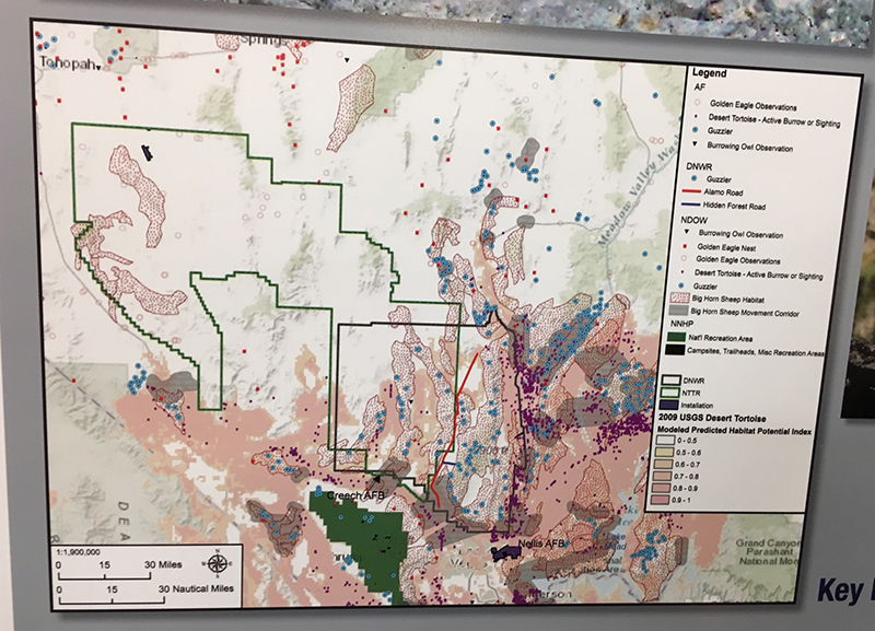
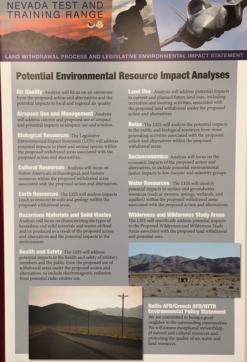
^Poster showing Biological Resources on the NTTR. We disagree with the number of tortoises supposedly within the South Range, there is a high density that may be in threat of live fire bombing.
Public Reaction
We saw no public support in the audience, only questions and concerns. At our Beatty meeting the attendance was relatively high, and many concerned ranchers drove in from as far away as Yerington. Discussions about access to traditional watering areas, grazing allotments, and other issues prevailed. All in a civil and polite manner. The upper Amargosa River, for example, has grazing on BLM land and this would be enclosed.
Beatty itself, a struggling former mining town looking to a future boosted tourism economy, even eco-tourism, would be squeezed by more land grabs, many say. Local entrepreneurs have developed mountain bike trails partly on private ranches and partly on BLM land to attract sport tourism to the area. We support this as a low-impact land use that can help the local economy and has a very low footprint on the landscape. In fact mountain bikers have started coming to Beatty to enjoy the desert scenery and professionally-designed and built trail system that offers miles of technical challenges and scenic tours. Part of this mountain bike trail system would be cut off by the military expansion. Other mountain bike trails were planned in areas of the proposed expansion, so Beatty's future may be squeezed tighter before it can grow.
Other locals made comments about how they hiked in these lands, rode their horses, and participated in 4x4 tourism on backcountry dirt roads.
This area would be fenced in with barbwire fencing and established dirt roads would be cut off and gated.
There was some discussion of shared use of the land with military, allowing public access for certain events or during certain seasons. But local people said this was preventing the development of new forms of tourism in these lands, with unanticipated times of use.
Ready Access of military lands might accommodate hunting in some areas, a topic repeatedly brought up. Many residents of Nevada were concerned about access being restricted to more and more lands in the state. The NTTR already locks up more than 2 million acres. We have taken oral histories of long-time residents people who remember traveling, hunting, recreating, gathering pinyon nuts, and ranching in the present NTTR before it was declared military land.
Informational brochure at meeting detailing Alternatives:
Scoping Begins for Nevada Military Land Expansion
August 28, 2016 - The Nellis Test and Training Range, and Naval Air Station in Fallon are seeking to expand to accommodate "new advanced technology." They want to take Bureau of Land Management land in exchanges, but this is amazing desert that we hike in and visit. We are asking for more maps to be provided. There will be public meetings--see the websites for listings.
We hope people speak up about this! That is your public land.
Nellis Test and Training Range Proposed Expansion
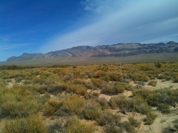
^The upper Amargosa River watershed which would be included in the proposed expansion.
June 8, 2016 - Following the approved Ft. Irwin and the 29 Palms Marine Base expansions, the US Air Force has a proposal to expand the boundaries of their range in central-south Nevada.
We talked to the Air Force about the large military expansion proposal for the range in Nevada which would potentially transfer up to 230,000 acres of public land to the military, mostly in the Mojave Desert.
They are proposing the following alternatives:
1. Keeping the existing range
2. Adding 18,000 acres to the base in the northern section
3. Adding 64,000 acres to the base along the west side of the South Range (this would include more of the upper Amargosa River watershed)
4. Adding 230,000 acres of land to the range along the east side of the South Range. This would all be BLM land and you would have no longer have access.
In August, scoping for Legislative Environmental Impact Statement will take place. At this time, maps will be released although the agencies have the maps now. This is all part of a request by Congress to expand the range and even remove some of the Desert National Wildlife Refuge.
Here is the text of the email we received from the Air Force concerning this expansion proposal:
The Air Force is in the process of evaluating proposals for the upcoming military land withdrawal of the Nevada Test and Training Range (NTTR). The current military land withdrawal of the NTTR expires in November 2021. We are going to be completing a Legislative Environmental Impact Statement (LEIS) over the next few years (2016-2018), beginning this summer (~ August) with public scoping meetings. We don't have maps of the proposed withdrawal alternatives finalized yet, as we are working with the land survey office to determine how proposed alternatives overlap existing legal boundary descriptions and how alternative boundaries will need to be adjusted. Alternatives being considered by the Air Force will evaluate renewal of the existing NTTR military land withdrawal in its current boundaries and configuration, will propose adjustments in land management and jurisdiction, will analyze several options for increasing the acreage of the existing withdrawal area to enhance testing, training and operational security; and will look at options for extending the duration of the existing withdrawal timeframe (20 years, 50 years, or making the military withdrawal permanent until such time as lands are no longer needed for military testing or training). Sub-alternatives for adding additional land to the NTTR will look at adding ~18,000 acres, ~60,000 acres, and ~230,000 acres in 3 separate areas around the NTTR.
More information will be forthcoming as the Air Force planning process for the NTTR land withdrawal moves forward, and public meetings will occur later this summer.
Sincerely,
Mike Ackerman
NEPA Division (AFCEC/CZN)
(210) 925-2741, DSN 945-2741
^The present boundary of the Nevada test and Training Range along the upper Amargosa River watershed north of Beatty.
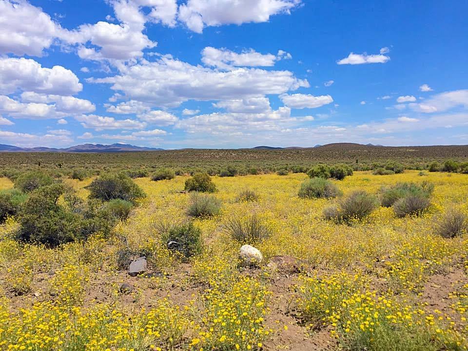
^Fileds of desert marigold (Baileya pleniradiata) in sandy soils along the upper Amargosa River north of Beatty, NV. Will this area be taken out of public access by military base expansion? It is currently Bureau of Land Management.